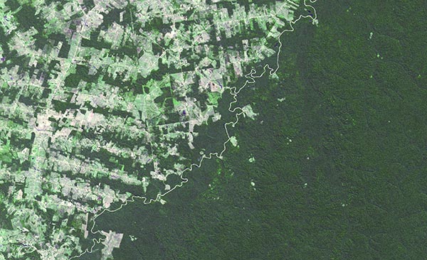
 Grazing land in the Brazilian rainforest
Rainforest converted into grazing land
The river visible on the image forms the border between the western Brazilian province of Acre (left), and the north-western Bolivian departement of Pando (right). The difference in land use is striking. Brazil has opened up this part of the rainforest to agriculture, predominantly cattle farming, which creates a herringbone pattern on the image. On the other side of the border however, in Bolivia, the natural rainforest has been preserved. According to the FAO, South America is the continent with the highest rate of deforestation; in the period 2000–2010, approximately 40 000 km2 was felled per year.
In 2012, the Amazon rainforest shrank by 4 571 km2. A large part of the deforested land in Amazonia is used or has been used for cattle farming. Some areas are also used for soya cultivation, with the crops being mainly exported to the US and Europe for use in animal feed. Photograph from 2008.
Photo: NASA/GSFC/METI/ERSDAC/JAROS, and U.S./Japan ASTER Science Team
Published: 2014
Share this article:
![]()
![]()
![]()
![]()